 |
Orlando |
 |
Code of Ordinances |
 |
Chapter 67. AFFORDABLE HOUSING |
 |
Part 6. ALTERNATIVE DEVELOPMENT STANDARDS FOR LOW AND VERY LOW INCOME HOUSING PROJECTS |
§ 67.606. Alternative Housing Transportation Standards.
(a)
Alternative Housing streets shall be designed to function as local streets. It shall be the responsibility of the developer to ensure the proper function where vehicular noise, congestion and speeds are minimized through the use of a combination of landscape, hardscape and road surface treatment. The street right-of-way and optional city services easement shall support multi-modal transportation including autos, pedestrians, and bicycles.
(b)
The internal street system shall be designed so that at least ninety percent (90%) of the street segments interconnect.
(c)
Wherever an Alternative Housing development abuts unplatted land or a future development phase of the same development, street stubs shall provide access to abutting properties or to logically extend the street system into the surrounding area.
(d)
Parking Standards/Residential Development.
(1)
Parking for single family and two family development shall be designed and constructed as a paved or acceptable alternative hard surface.
(2)
All required parking spaces for single family and two family development shall be located outside the required front yard setback. For two family development, on-street parking directly abutting a lot may be counted toward fulfilling the off-street parking requirement except where lot width, driveway widths or location, street widths or other right-of-way design elements limits the number of available on-street parking spaces. One parking space credit shall be given for each full space abutting a lot on streets with a minimum 24′ wide pavement width, not including curb and gutter. Where an on-street space abuts more than one lot, no parking space credit shall be given. Where on-street parking is credited, access drives shall be situated so that there is a minimum of one full parking space in front of each lot.
(e)
Those streets determined during Preliminary Plat or Short Form Plat review to function as residential collectors shall conform with the standards established in Chapter 61 or as modified by the City Transportation Engineer and City Engineer. Those streets determined to be classified higher than a residential collector shall conform to the Land Development Code Access Management Standards. Alleys and One way Local Streets shall be permitted only at the discretion of the Public Works Director and the Planning Official. The remaining streets shall conform with the following cross section standards:
(1)
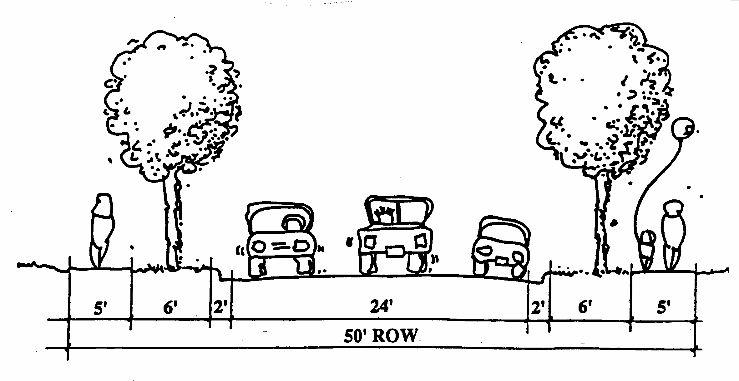
AH Local Street #1: Provides access for service vehicles and access to adjacent land use. Local Streets #1 should carry only traffic having either destination or origin on the street itself. Local Streets #1 may interconnect with streets outside the Alternative Housing development.
Land Use: Single family, two family.
Max. Density: 12 du/ac.
Specs Alternative Specs
50′ ROW 40′ ROW (sidewalks located in easements outside of the right-of-way) 24′, 20′, or 18′, total pavement widths* 24′, 20′, or 18′ total pavement widths* Two 5′ wide sidewalks Two 5′ wide sidewalk easements Two 6′ wide parkways** Two 6′ wide parkways** Two unmarked travel lanes Two unmarked travel lanes Parking lanes* Parking lanes* 15′ minimum curb radii 15′ minimum curb radii 25 mph posted speed limit 25 mph posted speed limit 2′ standard curb and gutter both sides 2′ standard curb and gutter both sides *Pavement Width and Parking Lane Alternatives:
a)
As part of the 24′ total pavement width, two unmarked parking lanes are permitted.
b)
As part of 20′ total pavement width, one unmarked parking lane is permitted with "no parking" signs posted by the developer on one side of the street.
c)
As part of the 18′ total pavement width, no on-street parking shall be permitted, and the developer shall be required to post "no-parking" signs on both sides of the street.
**The 6′ wide parkway can be reduced to 3′ wide with the approval of the City Engineer and City Transportation Engineer.

AH LOCAL STREET #1
(2)
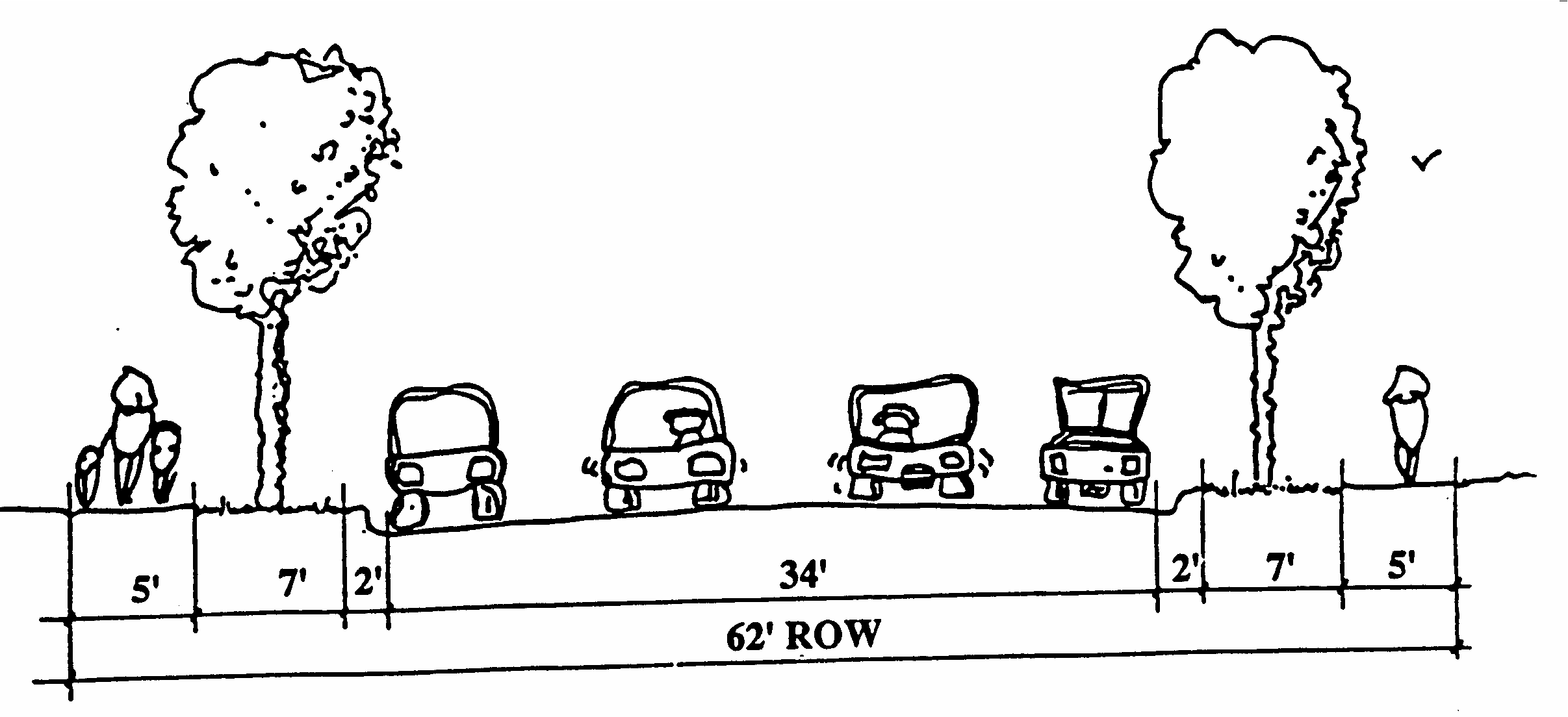
AH Local Street #2: Provides access for service related vehicles and access to adjoining land use. The Local Street #2 may carry a small amount of residential through traffic generated from AH local streets.
Land Use: Single family, two family.
Max. Density: 21 du/ac.
Specs Alternative Specs
62′ ROW 50′ ROW* (sidewalks located in easements outside of the right-of-way) 34′, 24′, 20′, or 18′ total pavement widths* 34′, 24′, 20′, or 18′ total pavement widths* Two 5′ wide sidewalks Two 5′ wide sidewalk easements Two 7′ wide parkways** Two 6′ wide parkways** Two unmarked travel lanes Two unmarked travel lanes Parking lanes* Parking lanes* 15′ minimum curb radii 15′ minimum curb radii 25 mph posted speed limit 25 mph posted speed limit 2′ standard curb and gutter both sides 2′ standard curb and gutter both sides *Pavement Width and Parking Lane Alternatives:
The parking lanes on AH Local Street #2 shall be unmarked unless striped parking is approved by the City Transportation Engineer.
a)
As part of the 34′ total pavement width, two unmarked parking lanes are permitted.
b)
As part of the 24′ total pavement width, two unmarked parking lanes are permitted.
c)
As part of the 20′ total pavement width, one unmarked parking lane is permitted with "no parking" signs posted by the developer on one side of the street.
d)
As part of the 18′ total pavement width, no on-street parking shall be permitted, and the developer shall be required to post "no-parking" signs on both sides of the street.
**The parkway widths may be reduced to 6′ to permit the 50′ alternative right-of-way width. The parkways can be further reduced to 3′ wide with the approval of the City Engineer and the City Transportation Engineer.

AH LOCAL STREET #2
(3)
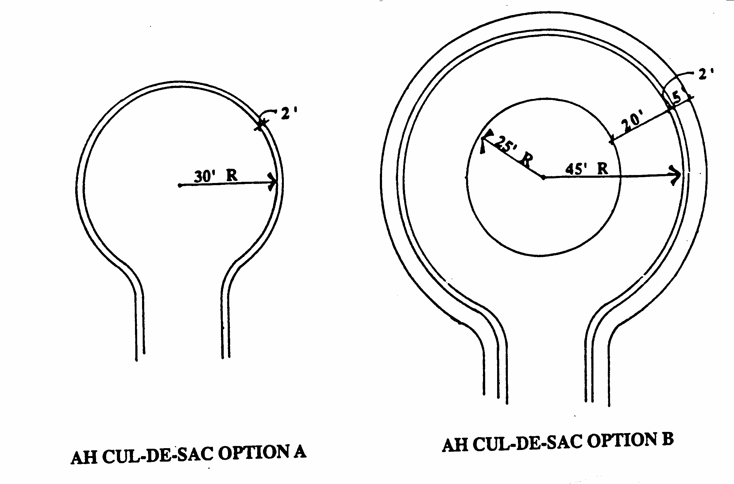
AH Cul-de-Sac: Purpose is to provide access for service vehicles and access to lower density land uses and to allow flexibility in the design of AH cross sections.
Land Use: Single family, two family.
Specs: (Both options align with Local Street #1):
Option A* Option B*
39′ radius ROW 52′ radius ROW 5′ sidewalk 25′ radius center landscaped island with curbs or decorative pavers 7′ wide parkway 7′ wide parkway 30′ radius paved area 20′ paved travel lane 15 mph posted speed limit 15 mph posted speed limit 2′ standard curb and gutter 2′ standard curb and gutter *Culs-de-sac shall be on street segments no longer than 700′. 7′ wide parkway is optional and can be reduced to 3′ wide with approval of the City Engineer and City Transportation Engineer.
No street parking shall be permitted on circle. "No parking" signs shall be installed by the Developer per the MUTCD.

AH CUL-DE-SAC OPTION A AND B
(Ord. of 2-22-1993, Doc. #26393; Ord. of 6-20-1994, Doc. #27637)